


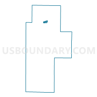
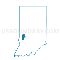
BRAZIL 04, Clay County, Indiana
About
Outline

Summary
| Unique Area Identifier | 576656 |
| Name | BRAZIL 04 |
| County | Clay County |
| State | Indiana |
| Area (square miles) | 0.59 |
| Land Area (square miles) | 0.59 |
| Water Area (square miles) | 0.00 |
| % of Land Area | 100.00 |
| % of Water Area | 0.00 |
| Latitude of the Internal Point | 39.52293960 |
| Longtitude of the Internal Point | -87.11219060 |
Maps

Graphs
Select a template below for downloading or customizing gragh for BRAZIL 04, Clay County, Indiana


Neighbors
Neighoring Voting District (by Name) Neighboring Voting District on the Map
- BRAZIL 01, Clay County, IN
- BRAZIL 02, Clay County, IN
- BRAZIL 03, Clay County, IN
- BRAZIL 05, Clay County, IN
- JACKSON 02, Clay County, IN
- JACKSON 03, Clay County, IN
- VAN BUREN 02, Clay County, IN
Top 10 Neighboring County Subdivision (by Population) Neighboring County Subdivision on the Map
- Brazil township, Clay County, IN (8,471)
- Van Buren township, Clay County, IN (3,528)
- Jackson township, Clay County, IN (2,739)